Wednesday, May 20, 2026
OKC → Pops 66 → Tulsa, Diana airport pickup
Giant soda bottle in Arcadia, pre-position at Mingo, evening run to TUL
- 132.6 miles
- ~3 drive hours
- Rockwell RV Resort, overnight 50A FHU first charge
- Mingo RV Park, Tulsa tonight
Weather: Plains spring, overcast cool start at OKC (55 to 60°F at 10 AM CDT per KOKC), light N/NNE wind ~7 mph, warming through the day across central OK. Storm risk in the afternoon.
The day, by the numbers
- Miles driven132.6mi
- Towing efficiency1.23mi / kWh132.6 mi · 107 kWh
- Energy107kWh used · 202 kWh charged across 2 sessions
- Peak charge rate8kW
- Wind8mph NEMostly headwind
- Temperature63°F55 – 70°F range
- Peak elevation1,230ft↑ 1,800 ft↓ 2,400 ft
- Avg speed40mph · 3.3 hr moving
Map loads with JavaScript. Each day page also lists every stop in text below.
Day 07 in pictures
Every photo from this trip → Browse all our photo galleries →
The day
-
Rockwell RV Resort, OKC morning
8:43 AM CDT first photo (interior wardrobe rummage for a Route 66 / Oklahoma shirt). 9:00 AM CDT outside in the puffy jacket, the rig still plugged into the 50A pedestal, 60°F overcast morning. Charge cable still connecting the pedestal-mounted NEMA 14-50 to the truck via the yellow Rivian portable adapter. Stuck the round blue Rockwell RV Resort sticker onto the Airstream sticker board (which now reads as a small map of the trip so far: Route 66 Holbrook, Petrified Forest, Big Bear Discovery Center, San Diego Airstream Club, the Amarillo KOA from two nights ago, and a brand-new Rockwell RV Resort badge). Hitched up around 10:10 AM. Trip A pre-departure: 1,612.7 mi at 1.29 mi/kWh, 1,250 kWh trip-to-date, average 45 mph over 1 day 11 hr 43 min moving. Trip B was not reset overnight, so it still read 254.6 mi / 219 kWh / 1.16 mi/kWh from the Buc-ee's reset two days back (Buc-ee's → Erick → OKC RAN → Rockwell, cumulative). Reset Trip B at the gate before rolling. Ambient 60°F, battery 65°F, motors 68 to 71°F, tires 46 psi front / 50 to 51 psi rear.
Segment data Map 35.4634, -97.6307
-
Kilpatrick Turnpike east through Edmond
Headwind on this leg 8 mph from the NE
Quick run NE from the Rockwell exit, up the Kilpatrick Turnpike toward Arcadia. Overcast morning, light NNE wind at ~7 mph, 55 to 60°F. Quartering headwind on the NE-bound diagonal, not enough to bite the efficiency.
Map 35.5500, -97.4500
-
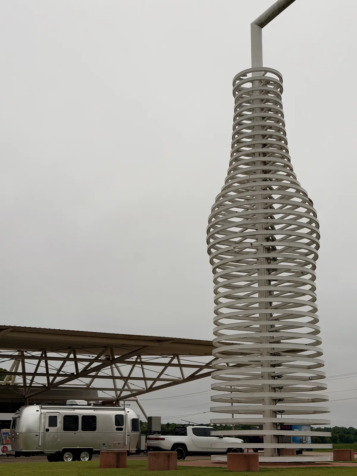
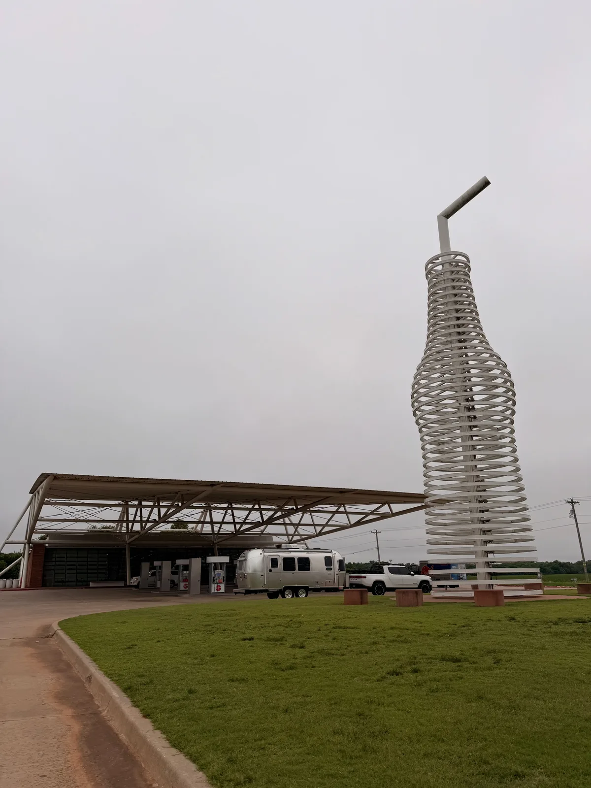
Pops 66 Soda Ranch
Headwind on this leg 8 mph from the NE
10:53 AM CDT arrival at 660 OK-66, Arcadia. 66-foot stainless-steel pop bottle by Rand Elliott Architects, the architectural canopy that sweeps over the gas + charge area, and a wall of 700+ sodas inside (the famous floor-to-ceiling glass-front fridges, organized by state and brand, with ARIZONA / NEW MEXICO Route 66 photo panels mounted above). Painted "Route 66 / OK / ARCADIA" shield on the road approaching the property. Pulled in under the canopy at 35.6588, -97.3356; spent ~25 min photographing the sculpture, browsing the soda wall, and pulling four-packs at the checkout (the rainbow-printed Pops 66 four-pack boxes are themselves part of the brand). Standout bottles spotted on the shelves: W.T. Heck Bacon Soda (top-hat mustache mascot, bacon-stripes label), Always Ask for Avery's Unicorn Yack (raspberry-orange-cane-sugar, the cartoon unicorn label), plus the Apple Pie soda and several Jones varieties.
Map Official site 35.6583, -97.3355
-
Arcadia Route 66 Centennial sign
11:35 AM CDT, ~0.7 mi east-northeast of Pops 66 at the next gravel pull-off. Big red-painted roll-up door on a wood-sided building, panel reads "Arcadia / 100 Miles of Christmas" banner above a black-and-white Route 66 shield with "1926 to 2026" centennial dates and CENTENNIAL on the blue-and-white striped banner below. Mission (the German Shepherd) posed for a shot at the sign with Eric on leash. The Arcadia Centennial sign is part of the town's recognition of the 100-year anniversary of US Route 66 (commissioned Nov 11, 1926); Arcadia hosts a "100 Miles of Christmas" lights drive on the same property in December.
Map 35.6627, -97.3227
-
Chicken Shack, Arcadia (lunch)
11:45 AM CDT lunch stop on the same property as the Centennial sign. Chicken Shack signage in red-and-yellow block letters on a black wood-sided storefront, with the Centennial roll-up door and the adjacent Hill's building completing the small Route 66 plaza. Interior is barn-style: corrugated metal ceiling, exposed ductwork, brick walls, a "WHISKEY / BEER" neon sign over the bar rail, sports TVs at the back, an Oklahoma-shaped Coca-Cola "REFRESHING OKLAHOMA" neon panel under the rafters, a black-and-white cotton Route 66 wreath next to a "Route 66 / Historic Route 66 / The Mother Road" tin sign on the back wall. Red-checkered tabletops, classic chicken-house menu.
Map 35.6627, -97.3227
-
Route 66 art totem near Luther / Wellston
Headwind on this leg 8 mph from the NE
12:57 PM CDT. Pulled the rig over on old Route 66 east of Arcadia for a roadside art piece, a tall mosaic / stained-glass totem in vivid patchwork color, framed between the R1T and the Airstream. The two-lane alignment through Luther and Wellston is the original Mother Road surface.
Map 35.6806, -97.0463
-
Welcome to Davenport Route 66 mural
Headwind on this leg 8 mph from the NE
1:26 PM CDT. The "Welcome To Davenport" painted Route 66 mural with the Oklahoma 66 shield, mounted on a building along the historic alignment in Davenport OK. Quick rig-in-frame shot.
Map 35.7104, -96.7654
-
Stroud Route 66 neon sign
1:39 PM CDT. The "Route 66 / Stroud / EST. 1892" neon sign on the main drag through Stroud, OK, the red-and-blue shield + script. Stroud is the home of the original Rock Cafe (a Route 66 institution and a Pixar Cars research stop) a block away.
Map 35.7490, -96.6643
-
Heart of Route 66 Auto Museum, Sapulpa
Headwind on this leg 8 mph from the NE
2:36 PM CDT. The Heart of Route 66 Auto Museum in Sapulpa OK, marked by a 66-foot-tall stylized gas pump (one of the tallest in the country) with a clock-faced globe on top, a vintage blue VW Beetle and a 1940s sedan parked out front. A big OKLAHOMA 66 shield mural on the brick wall made the frame with the R1T rear + Airstream. Photo stop, did not tour the collection.
Map Official site 35.9960, -96.1300
-
Mingo RV Park, Tulsa
Headwind on this leg 8 mph from the NE
~3:10 PM CDT arrival at 4536 N Mingo Rd, the gated park 5 min from TUL. Log-cabin office (Camp Mingo) with the Oklahoma flag + a carved totem out front. Set up the Airstream on the 50A FHU site and plugged in for the overnight charge. Final Trip B for the day: 132.6 mi at 1.23 mi/kWh, 107 kWh. Trailer stays here; the airport run is truck-only.
Segment data Map Official site 36.1667, -95.8671
-
Tulsa International Airport (TUL) Caution
Diana lands 6:45 PM. Leave Mingo by 6:15 PM. TRUCK ONLY, trailer stays at Mingo.
Map Official site 36.2012, -95.8850
Towing segments this day
The charge-to-charge data, leg by leg.
Every towing leg logged today off the Rivian dashboard, with its elevation profile. Open one for the full per-segment data: efficiency, energy, grade, wind, temperature, and battery state of charge.
Where the electrons come from
-
Level 2 (50A NEMA 14-50, FHU)
Rockwell RV Resort, overnight 50A FHU
720 S Rockwell Ave, OKC 73128. 50A pull-through full-hookup site. Plugged in on arrival ~5:45 PM CDT on Day 6 with the pack at 30 percent SoC; left the rig plugged through the night via the included Rivian portable charger (the yellow NEMA 14-50 adapter). Site fee included the electric draw; no per-kWh charge. Departed at 10:17 AM CDT on Day 7 with the pack at 100 percent.
-
Level 2 (50A NEMA 14-50, FHU)
Mingo RV Park, Tulsa, overnight 50A FHU
4536 N Mingo Rd, Tulsa. Arrived ~3:10 PM CDT after the day's 132.6 mi run, plugged into the 50A FHU. No DC fast charge needed all day; the overnight shore power covers the next leg the same way Rockwell did. The planned Tulsa Memorial Tesla Supercharger top-up was skipped because the rig had plenty of range to reach Mingo and charge overnight.
Detailed charging data
4 receipts, app screens, pedestal displays, and Rivian dashboard readouts. Click through with the arrows; tap the tile to view full size.